Problem
A Wake County business has requested an analysis of their customer base for the purpose of identifying underserved areas in the county. The business has a database of customer information, including street addresses for each, but does not have an effective way to analyze distribution patterns, or where the customers are in relation to one another. The business will use the generated information to aid in formulating expansion strategies into underrepresented areas.
Analysis procedures
Strategies: Geocoding tools in ArcGIS ArcMap will be used to locate customers within a Wake County map. The business has provided relevant customer information in an Excel file. Two strategies will be employed and compared for usefulness to the goals of the business. The first will be to geocode customers according to their Wake County zip code, which will ultimately provide a distribution of customers per zip code. The second strategy will geocode street locations for each customer and thus should therefore provide a finer granularity of detail to the business about the location of each customer.
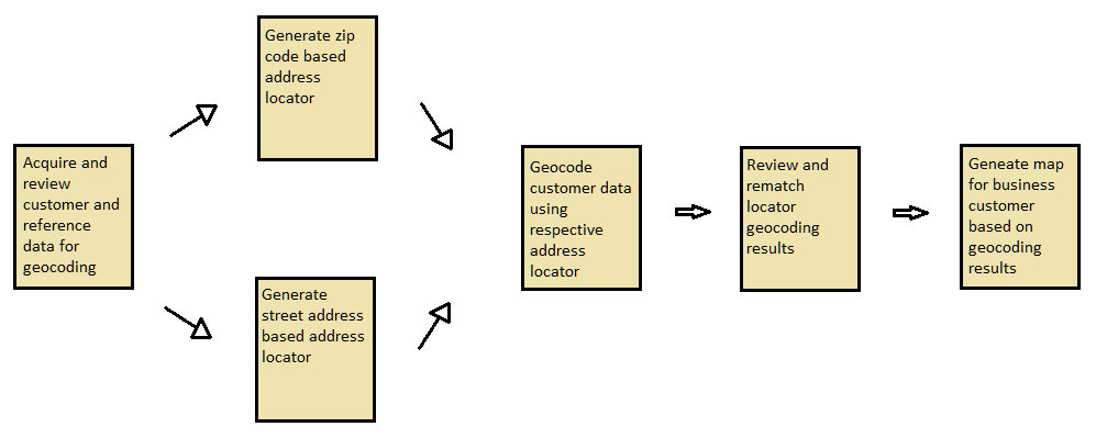
Methods: Geocoding locates tabular style data in a spatial frame of reference by utilizing reference spatial data and as such it is essential to initially examine the tabular data especially as it relates to the reference data. Two address locators are used in this analysis to ultimately generate two different styles of results and map presentations. The first address locator is zip code based (US Address – ZIP 5-Digit) and the reference data required is Wake County zip code boundaries. The second address locator is street address based (US Address – Dual Range) so a Wake County street layer is required as reference data. In each case the appropriate address locator was generated and then associated with the appropriate data layer.
The customer tabular data already contained a zip code field (ZIP_CODE) and this field was directly used for matching customers in the zip code based locator case. The customer data was not directly usable by the street address locator because the necessary information was split into two fields. As such a new table field was generated and populated with the concatenated street and zip code values required for the matching.
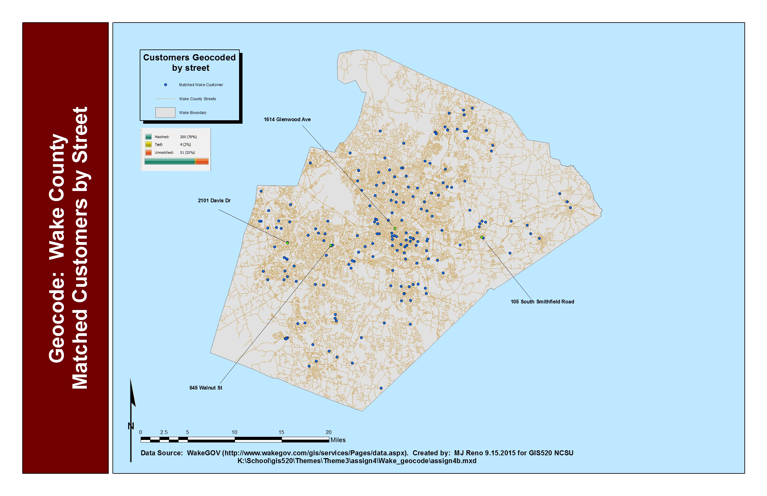
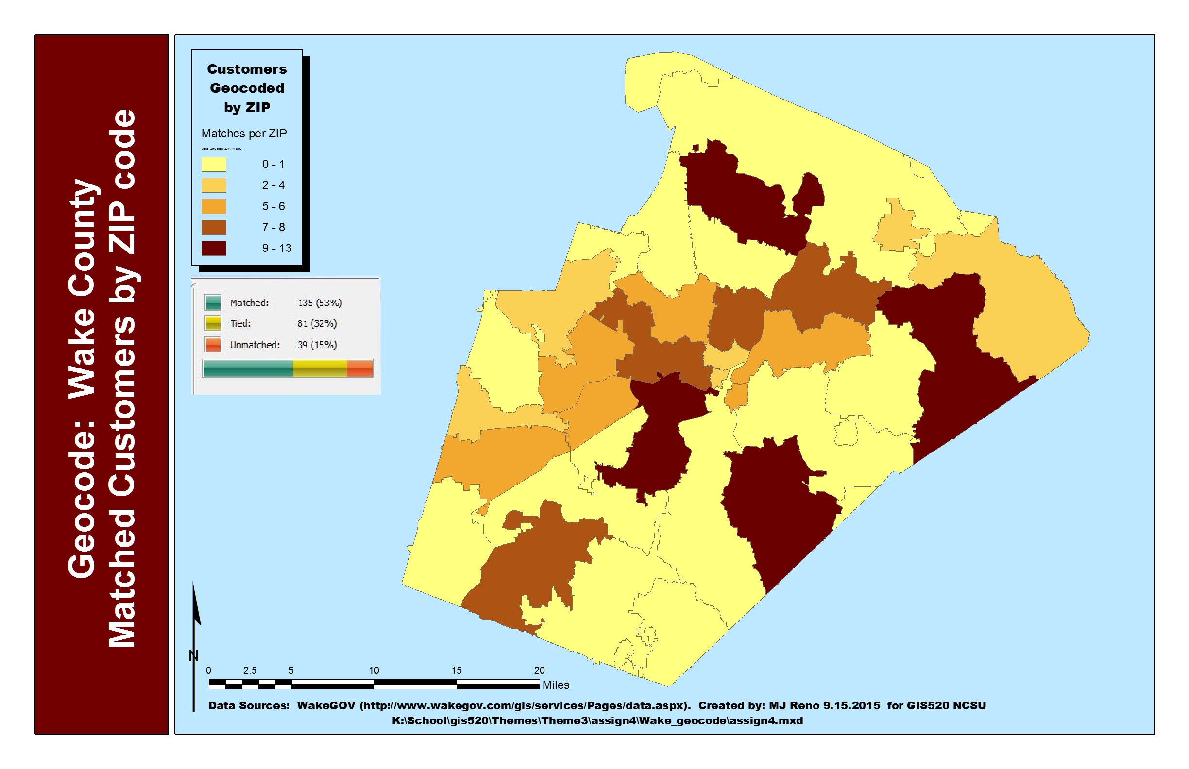
The geocoding results in each case were reviewed and a small subset of unmatched customers was corrected. In the street locater based case, 4 specific customers were exemplified and marked for the final map. Maps were generated for each geocoding result, showing 1) a distribution of matched customers per zip code (for the zip code based locator results) and 2) specific locations of customers in Wake County (for the street based locator results).
Results
Customers Matched by Street:
Customers Matched by ZIP Code:
Application and Reflection
Problem Description: Consider a historian that is writing a book about the events relevant to the civil war in North Carolina. The book is to include a map of sites discussed.
Data Needed: Tabulated lists of locations (some perhaps by street address, others by longitude/latitude, etc).
Analysis Procedures: Geocoding is used, after identifying appropriate reference data layers, to locate sites in an era specific map of North Carolina.